Severe Weather Risk With Large Hail Exists For East Texas Friday
It's that time of the year where we've got to be vigilant and stay weather aware.

Portions of East Texas have already seen several rounds of spring storms roll though producing some severe weather along with spawning a few tornadoes already this season. Friday is shaping up to be another one of those days that we'll want to pay close attention to the weather as a cold front approaches the area late Friday afternoon and evening.
KLTV 7 Chief Meteorologist Mark Scirto has issued a First Alert Weather Day for Friday afternoon and evening for much of East Texas because of the Storm Prediction Centers' forecast of potential strong to severe thunderstorms that will be possible along and ahead of a cold front that will be moving through.
It's the first time this season that much of the area is under a slight risk for thunderstorm development while a huge section of our central, eastern and central counties are under an enhanced risk, meaning there's a 30% chance of a severe weather event.
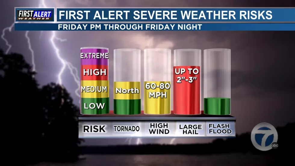
Along with the potential of strong storms, the Storm Prediction Center says there's a low risk of tornadoes in southern and eastern counties, but a medium risk in our northern counties. The other risks from these storms could be 60 - 80 mph winds and a high risk of rather large hail. Some storms could produce hail as large as 2 - 3 inches.
In the event of severe weather, we'll keep you updated from the First Alert Storm Team from KLTV 7. Stay weather aware Friday afternoon and evening.
Severe Weather Possible In East Texas Friday
KEEP READING: What to do after a tornado strikes
Hacks For Storm Preparation
Keep Reading: Other Useful Tips For Storm Preparation
Keep Reading: Items You'll Need In Case You Need To Evacuate
More From KKTX FM


