
At Least 7 Tornadoes Ripped Through East Texas Friday; Damage Surveys Continue

The National Weather Service has confirmed at least seven tornadoes touched down in East Texas last Friday (November 4th) in advance of the cold front that moved into the area. The Storm Prediction Center out of Norman, OK had warned that numerous tornadoes would be possible ahead of the cold front and that was indeed the case.
The first tornado warning was reported at about 3:45 for Rockwall County and from there someplace in East Texas was under a tornado warning until about 9:15. The KLTV 7 weather team worked overtime to keep East Texas informed as there were multiple warnings being issued at that the same time that covered cities like Athens, Tyler and Gilmer. Many warnings were radar indicated that thankfully didn't touch down, but there were quite a few that did and left behind a trail of damage.
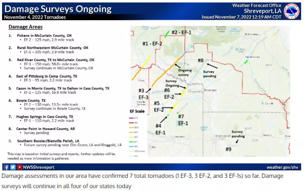
Teams from the National Weather Service (NWS) have been in East Texas assessing the damage and plotting the path of these destructive storms. So far, the NWS has confirmed that seven tornadoes did touch down and they are still examing many other areas in East Texas.
Confirmed tornadoes that touched down in East Texas as reported by KLTV 7 and CBS 19 via the NWS.
- Hopkins County - southwest of Sulphur Springs - rated EF-2 with max winds of 120 mph and had a path of nearly 3 miles
- Hopkins County/Rains County line - rated EF-1 with max winds of 100 mph - about 4.47 miles in lenght and was about 50 yards wide
- Lamar County - rated an EF-3 with max winds of 160 mph - was about 11 football fields wide (1350 yards) and traveled 22.3 miles into southeast Oklahoma
- Red River County - rated EF-3 - west of Clarksville inot McCurtain County, OK near Broken Bow, OK
- Camp County - east of Pittsburg - rated EF-1 with max winds of 95 mph with a path of a little over 2 miles
- Camp Coutny/Bowie County - rated an EF-2 with max winds of 125 mph
- Henderson County - rated an EF-2 with max winds of 115 mph - this storm formed south of Malakoff and traveled northeast through Athens and was on the ground for about 15 miles and was about 150 yards wide
- Morris County - west of Daingerfield - rated EF-2 with max winds of 125 mph - this tornado was on the ground for about 17 miles
Cass County - Hughes Springs - rated EF-1
Many East Texans captured these tornadoes and their aftermath on video. It is never a good idea to capture a tornado on video if it is nearby, you should seek shelter immediately and protect yourself.
@maxvelocitywx INSANE TORNADO EVOLVING in Sulphur Springs, TX - #tornado #fyp #foryoupage #tornadoes #weathertok #weather #wx #insane #wow #omg #weathers #storm ♬ original sound - Max Velocity
@turbulancelikely Supercell meso crossing I-30 in Sulphur Springs, TX #fyp #severeweather #texas #tornado ♬ original sound - Taylor
How are tornadoes classified?
Tornadoes are classified using the Enhanced Fujita Scale which is based on wind speeds produced by the tornado. The scale begins at EF-0 with minimum winds of 65 mph to an EF-5 with winds in excess of 200+mph.
Enhanced Fujita Scale
Rating Wind Speed Damage
EF-0 65- 85 mph minor
EF-1 86- 110 mph moderate
EF-2 111 - 135 mph extensive
EF-3 136 - 165 mph severe
EF-4 166 - 200 mph extreme
EF-5 200+ mph incredible
What to do when you are in an area that is under a tornado warning.
Find shelter in the most sturdy building you can. Be on the lower level of any building. Put as many walls as you can between you and the outside of the building. If you are in a car, find a low-lying spot (ditch, near the culvert) and cover your head. If you are in a manufactured home or travel trailer, seek shelter in the most sturdy building you can. Stay away from windows and use blankets to protect yourself from flying debris.
LOOK: The most expensive weather and climate disasters in recent decades
Gallery Credit: KATELYN LEBOFF
KEEP READING: Get answers to 51 of the most frequently asked weather questions...
You Could Find the Perfect Look for a Whataburger Fan this Christmas
Gallery Credit: Whatastore
More From KKTX FM


